
Eliot has a lot of old cemeteries. And Eliot, most likely, has a few old, lost cemeteries. This is the story of one of those cemeteries that may have been lost to memory for 166 years.
 |
| Book 253 Page 96 Alvin Libbey to Nathan Paul |
What makes this deed even more interesting is the fact that Nathan Paul sells this 15 acre parcel to Samuel W. Staples three years later in 1860. However, the deed from Nathan Paul to Samuel W. Staples does not explicitly mention the burying ground.
 |
| Book 268 Page 90 Nathan Paul to Samuel W. Staples |
The deed does say it is "Subject to all the reservations and granting all the privileges conveyed" in the previous deed, but the explicit description of the Libbey burying ground is no longer there.
Samuel W. Staples owned this parcel of land for over 40 years until he deeded it along with some other parcels to his son Nathaniel D. Staples near the end of his life in 1902. This deed was in Book 553 Page 266.
Again this deed does not specifically describe the Libbey burying ground but grants all of the prior privileges conveyed in the earlier Alvin Libbey deed. This deed to Nathaniel D. Staples was signed in 1893 but not recorded until 1906.  |
| Book 553 Page 266 Samuel W. Staples to Nathaniel D. Staples |
The reason for this late recording is that by then Nathaniel D. Staples had moved to Massachusetts and filed for bankruptcy in 1906. The property that was deeded to him by his father Samuel W. Staples was sold as part of a bankruptcy settlement to George E. Ireland and recorded in Book 556 Page 261.
It appears that Sylvester Staples passes down this 22 acres of land to his son Victor Staples because in 1951 Victor Staples deeds this land as one of six separate parcels to Roland S. Morse in Book 1326 Page 191.
 |
| Book 556 Page 261 George E. Ireland acquires in bankruptcy |
George E. Ireland then sells the parcels he acquired in this bankruptcy sale to Sylvester Staples in 1909. This deed is recorded in Book 592 Page 289. By this time the deed combines the parcels into a 22 acre parcel and makes no mention of the previous deeds and nothing about a burying ground.
 |
| Book 592 Page 289 George E. Ireland to Sylvester Staples |
 |
| Book 1326 Page 191 Victor Staples to Roland S. Morse |
And finally Roland S. Morse deeds these parcels to William and Daniel Seaward in 1968 in Book 1799 Page 384 and this begins the time when this part of Eliot on Route 236 becomes an industrial area. The lands become part of the Seaward Realty Trust in 1976 and in 1996 Seaward trust deeds all of the lands to Casella Tires in Book 7982 Page 165. This is when the recycling operations began in this area.
 |
| 1960 plan for Route 236 showing Roland Morse |
 |
| Original distance between stonewalls |
 |
| Original Baylands parcels 1699 |
Alvin Libbey who sold the 15 acre parcel to Nathan Paul was the son of Thomas Libbey. Thomas Libbey was the son of Seth Libbey. They were all descendants of Matthew Libbey who owned the narrow parcel of land that ran from the Piscataqua River all the way to the Marsh Hill area which is now part of Littlebrook Airport. Matthew and his brother David owned two of the five parcels that made up the Baylands. Together they built and maintained a lane between their two parcels from one end to the other, today known as Libbey Lane.
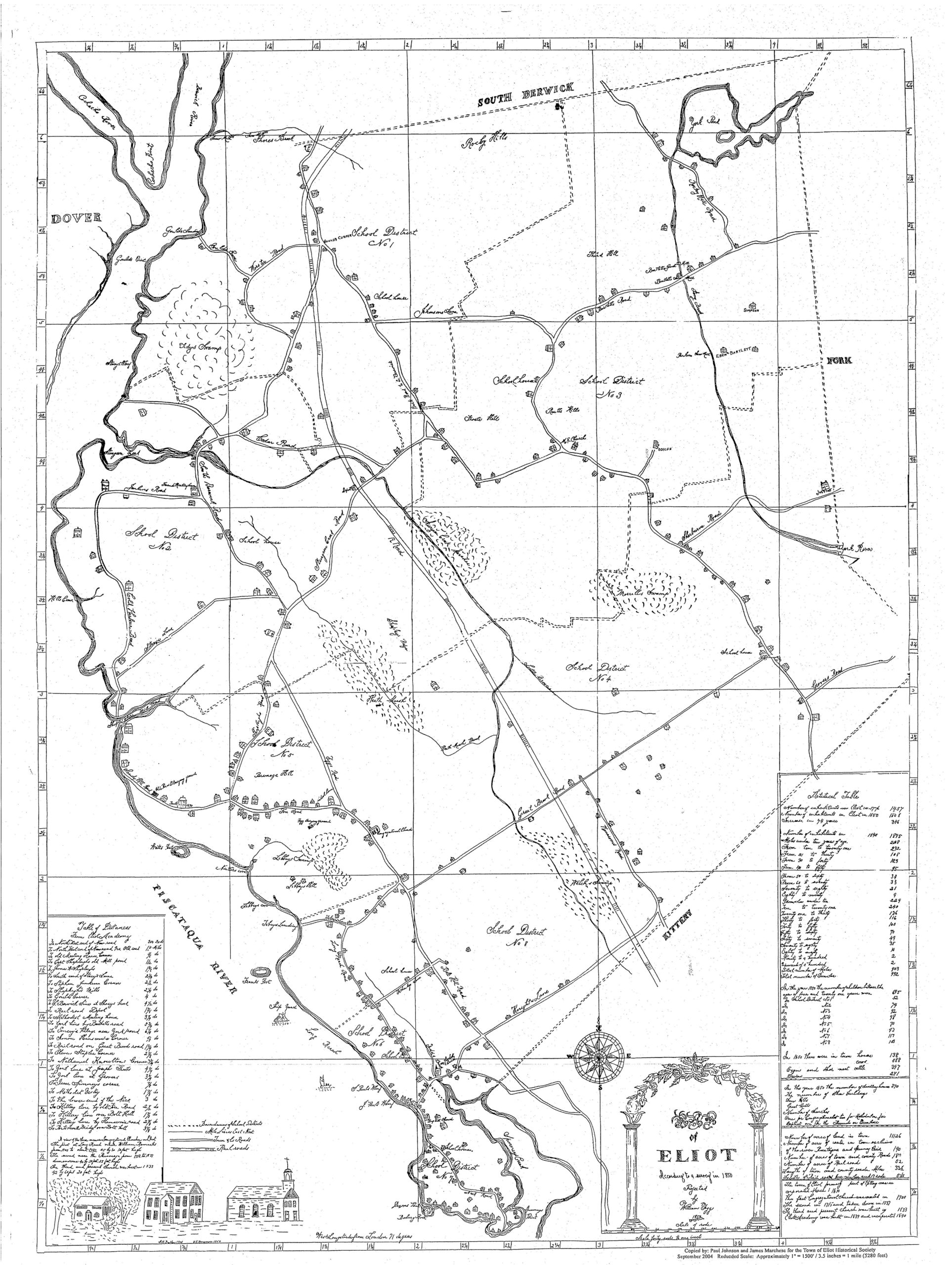
Seth Libbey built a house close to the river and, in the late 1700's, moved this house further inland close to where the railroad would eventually come through. Seth Libbey died here in 1794. His son Thomas lived here until his death in 1852.
 |
| 1850 map showing Seth Libbey house (circled) |
Seth Libbey built a house close to the river and, in the late 1700's, moved this house further inland close to where the railroad would eventually come through. Seth Libbey died here in 1794. His son Thomas lived here until his death in 1852.
The 15 acres that Alvin Libbey deeds to Samuel W. Staples appears to be all of the property that Alvin inherited from Thomas on the northeastern side of the railroad.
And where is the cemetery mentioned in the original deed of 1857? The northwest corner could be the corner of the lot that is today closest to the Hissong concrete plant. We would have to explore that corner of land currently owned by Black Hawk Holdings and see if there are any remnants of stones that could indicate an old burying ground. From the description it appears to be a long and narrow cemetery (57 feet by 16 feet), and the oldest burial would most likely have been Seth's in 1794.
 |
| Alvin's 15 acre parcel today |
Resources
York County Registry of Deeds Online: https://searchiqs.com/meyor/login.aspx
Eliot GIS map: https://next.axisgis.com/EliotME/#
William Fogg 1850 map: https://eliothistoricalsociety.org/wp-content/uploads/2022/09/1850-Fogg-Map-scaled.jpg
Libbey Family History: https://archive.org/details/libbyfamilyiname00libb/mode/1up?ref=ol&view=theater


No comments:
Post a Comment